
संक्षिप्त सारांश
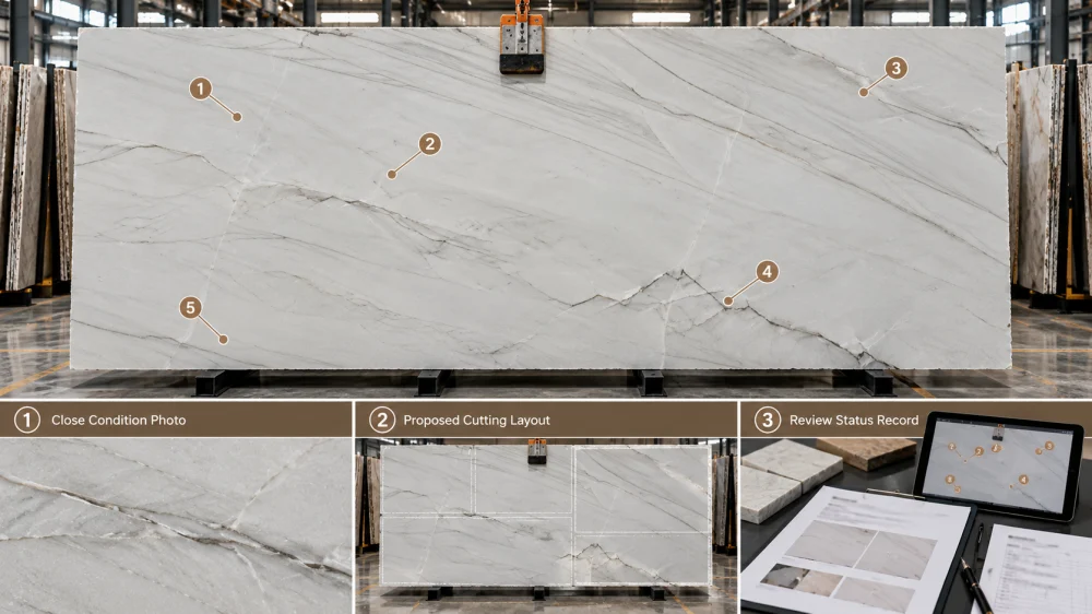
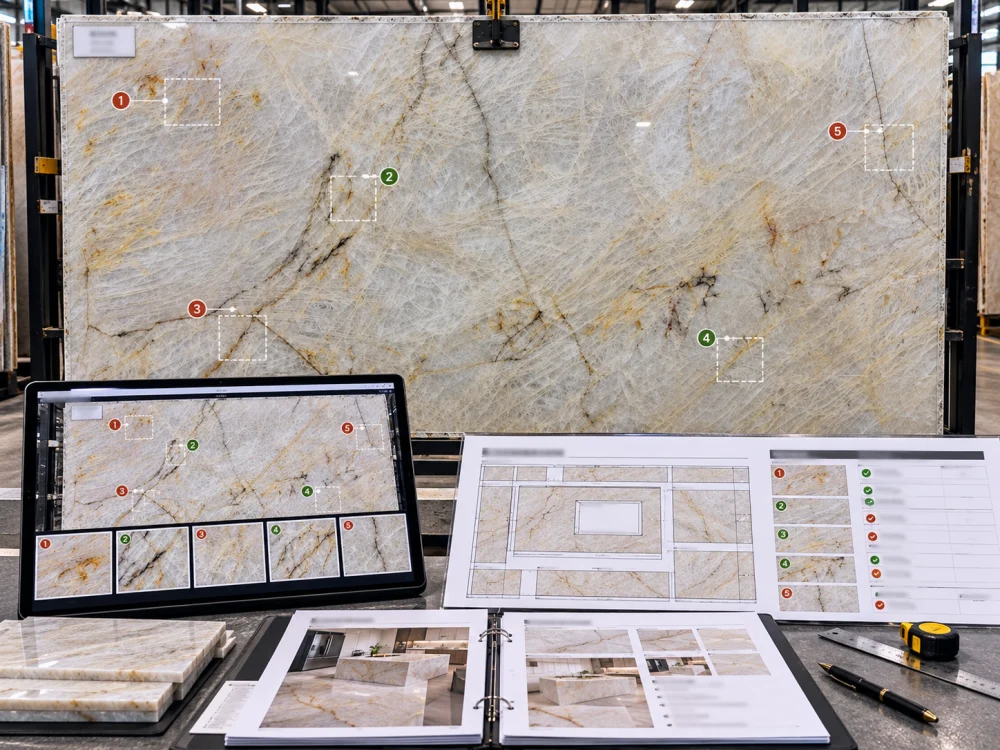
एक क्वार्ट्ज़ाइट स्लैब कंडीशन मैप एक विशिष्ट स्लैब की पहचान करे, एक सुसंगत दृश्य अभिविन्यास स्थापित करे, निरीक्षित स्थितियों को स्थिर कॉलआउट नंबरों के साथ चिह्नित करे, उन कॉलआउट्स को फोटोग्राफ्स से जोड़े, निरीक्षणों का निष्पक्ष वर्णन करे, और बताए कि किन आइटम्स को लेआउट या फैब्रिकेटर की समीक्षा की आवश्यकता है। जब कटिंग लेआउट मौजूद होता है, तो मैप अधिक उपयोगी हो जाता है क्योंकि यह दिखाता है कि निरीक्षित स्थितियाँ तैयार टुकड़ों, दृश्य क्षेत्रों, कटआउट्स, किनारों और वेस्ट ज़ोन के संबंध में कहाँ स्थित हैं। एक कंडीशन मैप एक समन्वय रिकॉर्ड है—न कि भूवैज्ञानिक निदान, गुणवत्ता प्रमाण पत्र या स्वचालित स्वीकृति निर्णय।.
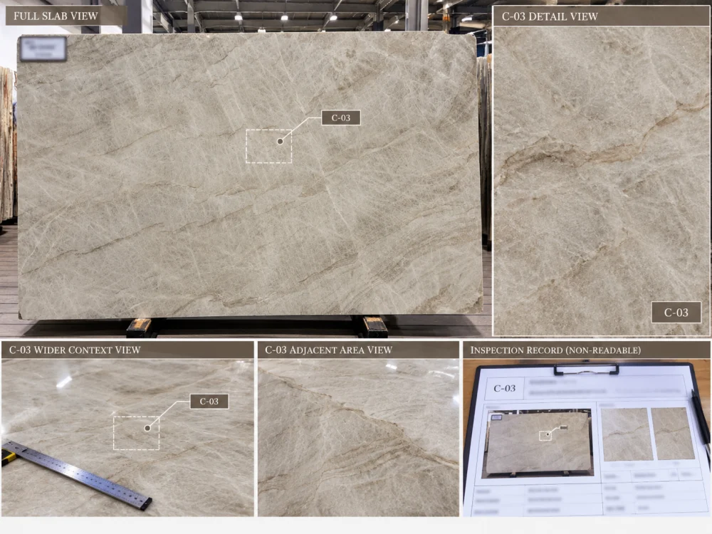
एक खरीदार को एक प्राकृतिक क्वार्ट्ज़ाइट स्लैब की छह क्लोज़-अप फोटोग्राफ्स प्राप्त होते हैं।.
एक फोटो में एक दृश्य रैखिक विशेषता दिखाई देती है। दूसरी फोटो में एक किनारे का चिप दिखाई देता है। तीसरी फोटो में एक भरी हुई जगह दिखाई देती है।.
फोटोग्राफ्स स्पष्ट हो सकते हैं, लेकिन परियोजना में अभी भी एक समस्या है:
ये स्थितियाँ स्लैब पर कहाँ हैं?
क्या वे एक साथ करीब हैं?
क्या एक भविष्य के सिंक ओपनिंग के अंदर पड़ता है?
क्या एक दूसरा आइलैंड के बीच में है?
क्या किनारे की स्थिति ट्रिमिंग के दौरान गायब हो जाएगी?
ए क्वार्ट्ज़ाइट स्लैब कंडीशन मैप उन स्थान संबंधी प्रश्नों का उत्तर देने के लिए डिज़ाइन किया गया है।.
इसका उद्देश्य पूरे स्लैब को “अच्छा” या “बुरा” लेबल करना नहीं है। यह भौतिक स्लैब, निरीक्षित स्थितियों, फोटोग्राफ्स, प्रस्तावित तैयार टुकड़ों और अनसुलझे परियोजना निर्णयों के बीच एक ट्रेसेबल संबंध बनाता है।.
कंडीशन मैप को एक स्लैब के चारों ओर निर्मित एक नियंत्रित पृष्ठ की तरह समझें।.
पूर्ण स्लैब आउटलाइन / रेफरेंस इमेज
ऊपर ↑
C-01 C-02 C-03
C-04 C-05
↓ नीचे
यह बुनियादी संरचना मैप को असंबद्ध निरीक्षण नोट्स के संग्रह में बदलने के बजाय, भौतिक सामग्री से जोड़े रखती है।.
पहला फील्ड इस प्रश्न का उत्तर देना चाहिए:
यह मैप किस भौतिक स्लैब का वर्णन करता है?
उपयोगी पहचान फील्ड में शामिल हो सकते हैं:
एक स्लैब = एक प्राथमिक मैप
यदि किसी परियोजना में कई प्राकृतिक क्वार्ट्ज़ाइट स्लैबों का उपयोग किया जाता है, तो सभी निरीक्षणों को एक व्यावसायिक सामग्री के नाम के तहत एक साथ न जोड़कर, प्रत्येक निरीक्षित स्लैब के लिए एक पहचान योग्य कंडीशन रिकॉर्ड तैयार करें।.
“पैटागोनिया क्वार्ट्ज़ाइट” एक सामग्री की पहचान करता है।.
लेकिन यह यह नहीं बताता कि कौन सा पैटागोनिया क्वार्ट्ज़ाइट स्लैब कंडीशन C-04 रखता है।.
अगली समस्या अभिविन्यास की है।.
यदि एक व्यक्ति स्लैब का फ्रंट से फोटोग्राफ लेता है और बाद में दूसरा व्यक्ति इस छवि को 180 डिग्री घुमाता है, तो “ऊपर-बाएं क्षेत्र” जैसा नोट अर्थहीन हो सकता है।.
इसलिए कंडीशन मैप को एक सुसंगत अभिविन्यास स्थापित करना चाहिए।.
TOP
नियंत्रित पूर्ण-स्लैब रेफरेंस के अनुसार निर्धारित किया जाता है।.
नीचे
Remains consistent across later photographs and layouts.
LEFT / RIGHT
Referenced from the same stated viewing direction.
ORIENTATION MARK
Helps connect photographs, condition map and later cutting layout.
Do not infer precise physical coordinates from a photograph unless the image or record provides an appropriate measurement basis.
Instead of writing several arrows saying “check here,” assign stable references.
उदाहरण के लिए:
C-01 — visible linear condition in upper-left area
C-02 — observed filled area near central zone
C-03 — edge chip at right perimeter
C-04 — strong colour transition
C-05 — area requiring closer photography before classification
The numbering system itself is not important.
Stability is.
If C-03 remains the same observed location after the layout changes, keep referring to it as C-03 rather than renaming the feature every time a drawing is revised.
This is one of the most important rules in a क्वार्ट्ज़ाइट स्लैब कंडीशन मैप.
OBSERVATION
“Visible linear condition crossing the marked area.”
UNVERIFIED CONCLUSION
“The slab has a structural crack and will break.”
The first statement records what the inspection can support.
The second makes technical claims that may require information not available from the photograph or visual inspection.
The same principle applies to words such as:
Use precise terminology when the condition is actually known. Otherwise, describe what is visible and identify what needs further review.
A condition map becomes confusing when the observation and the decision are written as if they were the same thing.
| फील्ड | Example |
| Condition ID | C-04 |
| Observation | Visible filled area in lower-right portion of slab |
| Evidence | Full-slab image + close photograph P-04 |
| Project Decision | Review against proposed island layout before cutting |
| स्थिति | Open — layout review required |
The condition itself does not automatically determine the project action.
Location, finished-piece geometry, visual priority and fabrication context may change what the team decides to do.
A close-up photograph can show detail very well while showing location very poorly.
That is why a useful photo record has two scales.
A condition photo without a location reference can easily become detached from the slab it is supposed to document.
The legend should be simple enough for buyers, designers and fabricators to interpret consistently.
Depending on the inspection scope, useful categories might include:
Do not create categories that imply the inspection established something it did not actually establish.
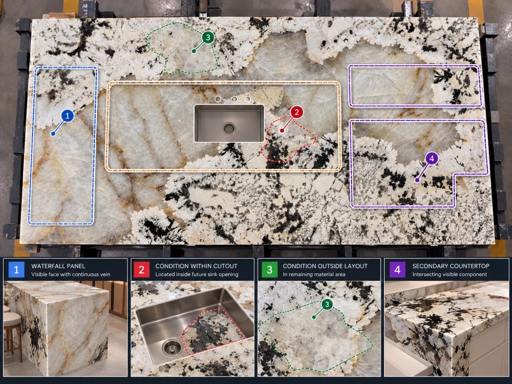
A condition map becomes substantially more useful once the project has a proposed cutting layout.
Now the team can ask a much better question than:
“Does this slab have a condition?”
It can ask:
“Where does C-04 fall relative to the finished project?”
LAYER A — CONDITION MAP
C-01 / C-02 / C-03 / C-04
LAYER B — CUTTING LAYOUT
Island / Waterfall / Vanity / Cutout / Waste / Spare
The result may show that an observed area:
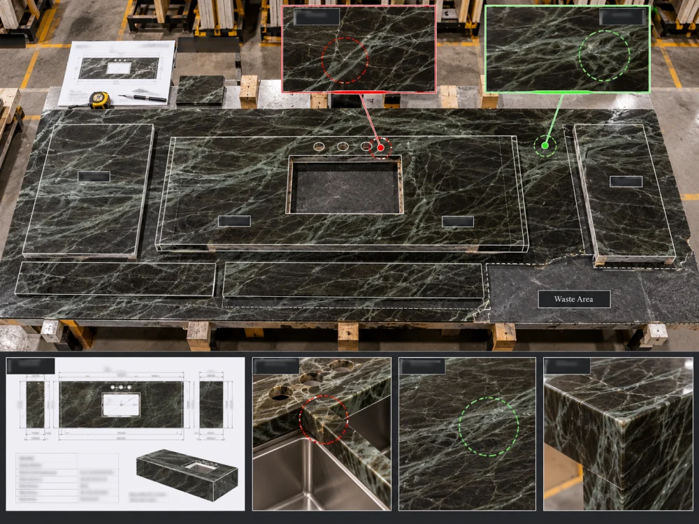
This location-based approach is also important when deciding whether an existing or proposed repair is acceptable. The site’s guidance on acceptable Natural Quartzite repairs similarly connects the actual slab condition to its finished-piece location rather than judging a repair only from an isolated close-up photograph.
A buyer may want to preserve a particular area for:
Marking a HOLD या MUST FEATURE zone can be useful.
Similarly, the project may mark an AVOID FOR THIS PIECE zone.
Important Distinction
A planning avoidance zone means the project does not currently want a particular finished component placed there. It does not automatically establish that the marked stone is defective, structurally unsuitable or unusable for every other purpose.
Without status, a condition map can become a permanent collection of unanswered arrows.
A simple status vocabulary may include:
INFORMATION ONLY
Observation recorded; no current project action required.
LAYOUT DECISION REQUIRED
The observation needs to be compared with proposed finished-piece placement.
FABRICATOR REVIEW REQUIRED
The condition intersects geometry or processing questions within the responsible fabricator’s scope.
MORE EVIDENCE REQUIRED
Additional photographs, dimensions or physical review are needed.
CLOSED — SEE REVISION
The project has recorded the relevant decision in an identified current document.
A professional condition map does not need to pretend that every observation can be resolved from the first photograph.
Useful notes include:
“Depth cannot be determined from photograph.”
“Back-side condition not shown.”
“Closer image required.”
“Actual dimension to be confirmed.”
“Review against cutting layout after piece position is fixed.”
“Fabricator review required before cutting.”
Visible uncertainty is more useful than unsupported certainty.
ए क्वार्ट्ज़ाइट स्लैब कंडीशन मैप can document:
What → Where → Evidence → Status
It does not automatically establish:
Those questions may require other documents or project-specific professional review.
Suppose condition C-05 initially falls outside the proposed island.
Then the island position moves.
C-05 may now fall directly inside a visible finished component.
The physical slab has not changed.
The project significance of the recorded location has.
REVISION EXAMPLE
Map R01
C-05 recorded → outside current island layout
Drawing Changes
Island position revised
Map / Review R02
Same C-05 → now intersects finished island → new review required
Preserve the earlier record rather than silently replacing it.
They may be overlaid for review, but they answer different questions.
| Condition Map | कटिंग लेआउट |
| Where was something observed? | Where are finished components proposed? |
| What evidence documents the observation? | How are pieces allocated to the slab? |
| What review remains open? | What material becomes finished piece, cutout, trim, spare or waste? |
Overlaying the two creates the useful project question:
Condition Location → Cutting Position → Finished Piece → Visible / Fabrication Context
The presence of a mapped condition does not automatically reduce usable slab area.
However, a project decision to keep certain observed areas out of specified finished components can change the available cutting envelope.
For example, several project-specific avoidance zones could:
This is why gross slab area should not automatically be treated as usable cutting area. The related प्राकृतिक क्वार्टजाइट का उपयोगी क्षेत्र बनाम सकल स्लैब क्षेत्र का गाइड explains how project-specific layout constraints can change practical yield.
A — Identity
Material name, exact board/slab ID, project reference.
B — Document Control
Inspection date, map revision, preparation basis and responsible record author/team.

C — Orientation
Full-slab reference, top/bottom/left/right and consistent viewing direction.
D — Stable Condition IDs
C-01, C-02, C-03 or another controlled numbering system.
E — Neutral Observation
What is visibly observed without unsupported diagnosis.
F — Location
Position on the actual slab.
G — Evidence
Full-slab photograph, close image, video or other identified record.
H — Layout Relationship
Finished-piece, cutout, edge, mitre, waste, spare or other relevant zone when the cutting layout exists.
I — Project Action
Information only, layout review, further evidence, fabricator review or another defined action.
J — Status
Open, pending, conditionally reviewed or closed under an identified project record.
K — Revision History
What changed when the map, layout or supporting evidence was updated.
बोर्ड: Identified Natural Quartzite slab
अवस्था ID: C-07
स्थान: Lower-central area on controlled full-slab reference
अवलोकन: Visible linear condition
साक्ष्य: Full-slab image F01 + close image P07
Initial Status: Layout review required
Layout Overlay: Proposed sink opening crosses most of the marked area; remaining portion approaches one finished corner
Next Action: Responsible fabricator to review actual condition and finished geometry before cutting release
Decision Record: To be updated after project-specific review
Notice what this example does not say.
It does not automatically call C-07 a crack.
It does not declare the slab defective.
It does not invent a universal safe distance from the sink.
It makes the physical relationship clear enough for the appropriate project party to review.
क्वार्ट्जाइट स्लैब की स्थिति मानचित्र एक नियंत्रित चित्रण या चिह्नित पूर्ण-स्लैब छवि होती है जो एक विशिष्ट प्राकृतिक क्वार्ट्जाइट स्लैब की पहचान करती है और स्थान, स्थिर कॉलआउट संख्या, समर्थन साक्ष्य तथा समीक्षा स्थिति के अनुसार देखी गई स्थितियों को दर्ज करती है।.
सामग्री और स्लैब ID, प्रोजेक्ट संदर्भ, निरीक्षण तिथि, संशोधन, सुसंगत स्लैब अभिविन्यास, संख्यांकित टिप्पणियाँ, तटस्थ विवरण, फ़ोटो संदर्भ, स्थान की जानकारी, समीक्षा की स्थिति और, जहाँ उपलब्ध हो, देखी गई स्थितियों और वर्तमान कटिंग लेआउट के बीच संबंध शामिल करें।.
जब किसी परियोजना में स्थिति मैपिंग की आवश्यकता होती है, तो प्रत्येक जांचे गए स्लैब को अलग-अलग पहचानने योग्य बनाए रखा जाना चाहिए। प्राकृतिक क्वार्ट्जाइट प्रत्येक स्लैब में भिन्न होता है, इसलिए एक बोर्ड के लिए बनाया गया स्थिति मैप दूसरे बोर्ड के लिए साक्ष्य नहीं माना जाना चाहिए।.
No. A condition map is a project coordination and inspection record. It does not replace a material specification, laboratory test, quality certificate, geological assessment, contractual acceptance procedure or fabricator’s technical review.
संबंधित दृश्यीय अवलोकनों का मानचित्रण किया जा सकता है, लेकिन उपलब्ध साक्ष्यों द्वारा समर्थित शब्दावली का ही प्रयोग करना चाहिए। एक प्राकृतिक विशेषता, पहले से पाए गए मरम्मत के तत्व, प्रस्तावित मरम्मत और निर्माण संबंधी सुदृढ़ीकरण को स्वचालित रूप से एक ही स्थिति के रूप में नहीं माना जाना चाहिए।.
उपयोगी होने पर, कटिंग लेआउट को स्थिति मैप के बगल में ओवरले किया जा सकता है या उसकी समीक्षा की जा सकती है। यह परियोजना को यह निर्धारित करने में मदद करता है कि देखी गई जगह एक तैयार टुकड़े, कटआउट, किनारे, मिट्रे, अपशिष्ट क्षेत्र या अन्य फैब्रिकेशन-संवेदनशील स्थान के अंदर आती है या नहीं।.
अनुमान लगाने के बजाय सीमा को दर्ज करें। जब अनुपलब्ध जानकारी किसी परियोजना के निर्णय को प्रभावित करती है, तो अतिरिक्त फोटोग्राफ, आयाम, भौतिक निरीक्षण या जिम्मेदार निर्माता की समीक्षा का अनुरोध करें।.
नहीं। एक स्थिति मानचित्र एक अवलोकन और स्थान को दर्ज करता है। परियोजना का निर्णय वास्तविक साक्ष्य, तैयार भाग की स्थिति, दृश्य आवश्यकता, निर्माण संदर्भ और लागू परियोजना मानदंडों पर निर्भर करता है।.
Condition Mapping for Natural Quartzite Projects
For condition-sensitive Natural Quartzite orders, HRST STONE can coordinate current full-slab photographs, board references, condition photographs, CAD/shop drawings, cutting layouts, piece IDs, fabrication review records, QC photographs and reinforced fumigated wooden-crate packing around the confirmed project scope. Send Josh the selected material, slab references, current drawings, dimensions, finish, visible areas, cutouts, edge requirements and any project-specific review priorities before cutting release.
© HRST STONE / XIAMEN HRST STONE CO., LTD. सभी अधिकार सुरक्षित हैं।.